
-
Research Article
-
Applicability of CryoSat-2 SARIn Mode for Monitoring Sea Level in the Ross Sea Polynya, Antarctica
CryoSat-2 SARIn 모드 관측의 남극 로스해 해수면 고도 관측 적용성 평가
-
Byeong-Hoon Kim, Hyeonsoo Cha
김병훈, 차현수
- In this study, we used CryoSat-2 Synthetic Aperture Radar Interferometry (SARIn) mode data to estimate sea surface heights from the reference ellipsoid …
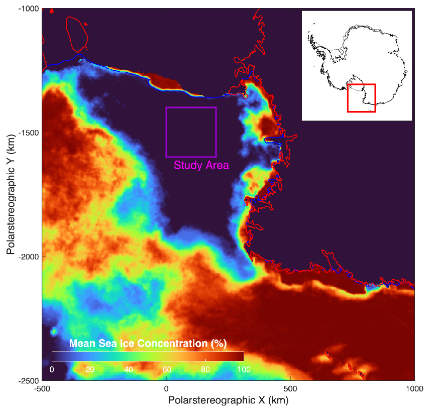
본 연구에서는 2010년 부터 2025년까지의 남반구 여름철(12월-2월)에 획득된 CryoSat-2 위성의 SARIn(Synthetic Aperture Radar Interferometry) 모드 자료를 활용하여 로스해 폴리냐 해역의 해수면 고도를 …
- In this study, we used CryoSat-2 Synthetic Aperture Radar Interferometry (SARIn) mode data to estimate sea surface heights from the reference ellipsoid within the Ross Sea Polynya during the austral summer months (December–February) from 2010 to 2025. To isolate pure sea surface signals from environments mixed with sea ice and icebergs, we implemented an empirical filtering method based on Pulse Peakiness and Backscatter Coefficient. The filtered sea surface heights showed a strong consistency with the EGM2008 geoid model (R2=0.98). Moreover, residual analysis indicated that the SARIn mode observations successfully reflect the dynamic sea level of the Ross Sea. The inter-annual sea level anomaly time series also showed good agreement with the global gridded products (r=0.63) from the Copernicus Marine Service (CMEMS). These findings confirm the potential of interferometric altimetry for monitoring polar coastal sea levels and provide a baseline for validating current and future satellite missions, including SWOT and CRISTAL.
- COLLAPSE
본 연구에서는 2010년 부터 2025년까지의 남반구 여름철(12월-2월)에 획득된 CryoSat-2 위성의 SARIn(Synthetic Aperture Radar Interferometry) 모드 자료를 활용하여 로스해 폴리냐 해역의 해수면 고도를 산출하고 그 정확도를 평가하였다. 해빙이나 빙산이 다소 혼재된 환경에서 순수 해수면 신호를 분리하기 위해, 파형 파라미터인 펄스 첨도(Pulse Peakiness)와 후방산란계수(Backscatter Coefficient)에 기반하여 경험적 필터링 기법을 적용하였다. EGM2008 지오이드 모델과의 비교 결과, 필터링된 해수면 고도는 모델과 높은 일치도(R2=0.98) 보였으며, 이상치를 제거한 잔차 분석을 통해CryoSat-2 SARIn 모드 관측이 로스해의 동적 해수면 변동 특성을 효과적으로 반영하고 있음을 확인하였다. 또한, 산출된 연별 해수면 변화 시계열은 공식적으로 배포되는 전 지구 해수면 자료(CMEMS)와 0.63의 높은 상관계수를 나타내어, 본 연구 결과의 신뢰성을 뒷받침하였다. 결론적으로 본 연구는 이를 통해 간섭계 기반 위성 고도계가 극지 연안 해역의 해수면 모니터링에 유효함을 입증하였으며, 향후SWOT 및 CRISTAL 등 차세대 위성 미션의 극지 데이터 검증 및 활용을 위한 좋은 기초 자료가 될 것으로 기대한다.
-
Applicability of CryoSat-2 SARIn Mode for Monitoring Sea Level in the Ross Sea Polynya, Antarctica
-
Research Article
-
Deep Learning-based Diffraction Separation Considering Time-Variant Characteristics
시변 특성을 고려한 딥러닝 기반 회절 분리
-
Junyon Park, Evan Um, Sooyoon Kim, SoonJee Seol, Joongmoo Byun
박준연, 엄찬기, 김수윤, 설순지, 변중무
- Diffractions in seismic surveys provide high-resolution information on subsurface heterogeneities and structures within reflection shadow zones. However, their small amplitudes and overlap …
탄성파 탐사에서 회절파(diffraction)는 지하 불균질성 및 미세 구조에서 발생하여 고해상도로 정보를 제공하며, 반사파 음영대 내 구조 탐지도 가능하게 하는 중요한 신호이다. 그러나 …
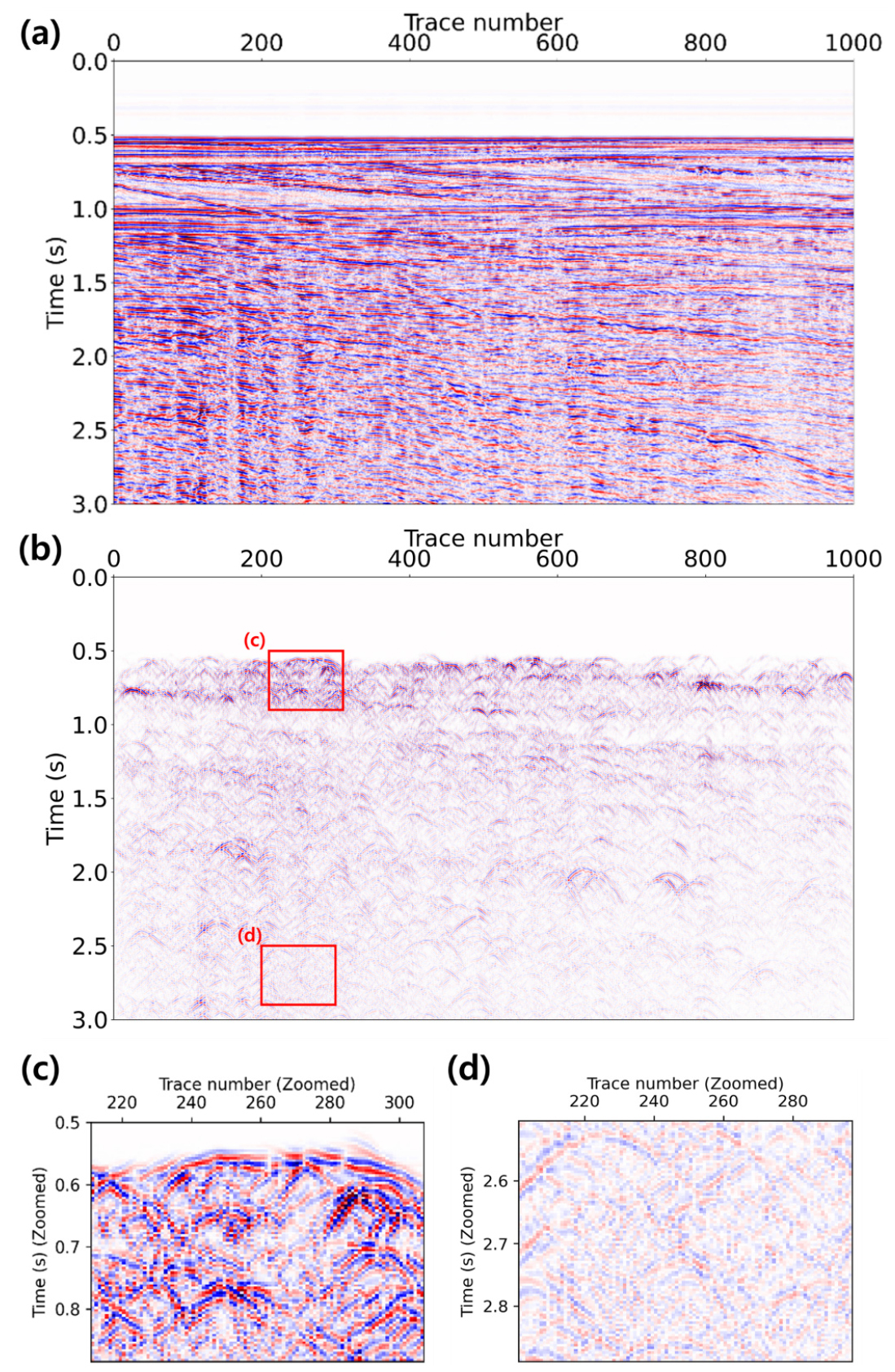
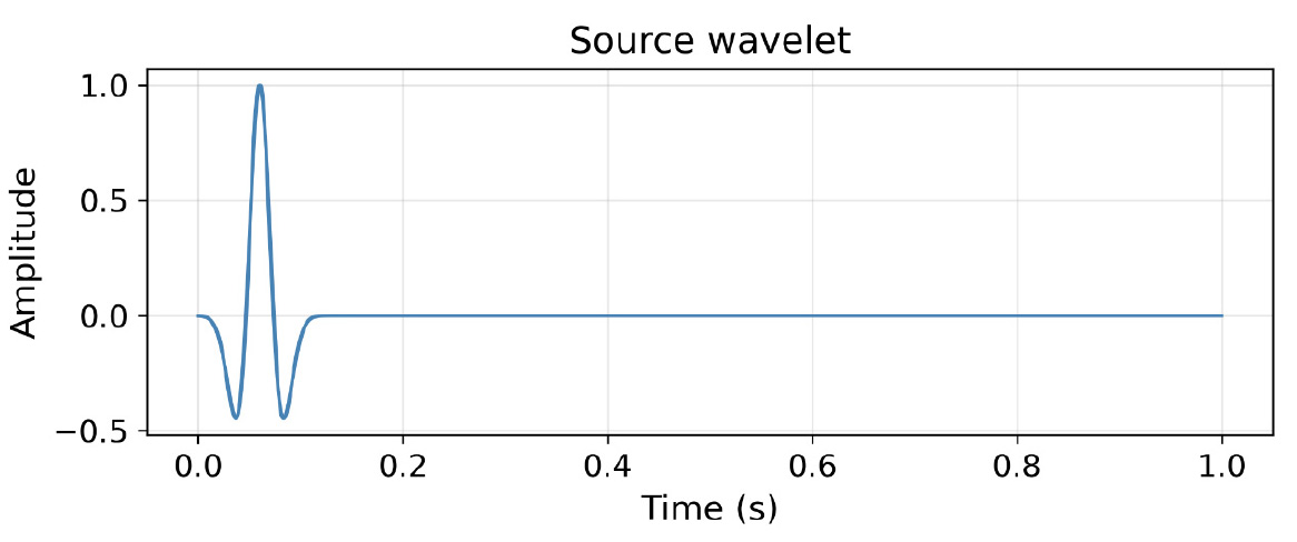
- Diffractions in seismic surveys provide high-resolution information on subsurface heterogeneities and structures within reflection shadow zones. However, their small amplitudes and overlap with reflections make extraction difficult. Even recent deep learning (DL)-based methods suffer from mis-separation if they fail to account for frequency attenuation and eccentricity variations over travel time. In this study, we improved the DL algorithm to reflect time-dependent signal characteristics. By adding a time-indicator channel, the model learns varying dominant frequencies and diffraction eccentricities across different time regions. For efficient data generation, the Kirchhoff diffraction formula was used instead of the finite-difference method. Application to the Mobil AVO Viking Graben Line 12 field data showed that misidentification—specifically late-time high-frequency noise and early-time low-frequency reflections—was significantly mitigated. Furthermore, the phase and amplitude of diffractions were more accurately preserved. This method is expected to be effective for seismic data with rapidly changing frequency characteristics or deep subsurface targets.
- COLLAPSE
탄성파 탐사에서 회절파(diffraction)는 지하 불균질성 및 미세 구조에서 발생하여 고해상도로 정보를 제공하며, 반사파 음영대 내 구조 탐지도 가능하게 하는 중요한 신호이다. 그러나 진폭이 작고 반사파와 중첩되어 전통적 기법으로는 분리에 어려움이 있다. 최근의 딥러닝(deep learning) 기반 회절파 추출 방법도 취득 시간에 따른 주파수 감쇠 및 이심률(eccentricity) 변화를 제대로 반영하지 못하면 오분리 문제가 발생할 수 있다. 본 연구에서는 기존의 딥러닝 알고리즘을 시간대별 신호 특성을 반영할 수 있도록 개선하였다. 입력 자료에 시간 지시자(time-indicator) 채널을 추가해 모델이 시간 대역별로 다른 주파수 및 이심률을 학습하도록 하였으며, 효율적인 대량 인공 회절파 생성을 위해 유한차분법 대신 Kirchhoff 회절파 공식을 도입하였다. 제안 방법을 Mobil AVO Viking Graben Line 12 현장 자료에 적용한 결과, 기존 방법의 후기 시간대 고주파수 잡음 및 초기 시간대 저주파수 반사파 오인 추출 문제가 크게 완화되었으며, 회절파의 위상과 진폭이 더 정확히 보존되었다.
-
Deep Learning-based Diffraction Separation Considering Time-Variant Characteristics
-
Research Article
-
A Feasibility Study on 3D Inversion of Grid-Based 2D Electrical Resistivity Data for Landfill Sites
격자형 2차원 전기비저항 자료를 이용한 매립지 3차원 역산 적용성 평가
-
Chul Hee Lee, Su In Jeon, Yongjae Lee, Yoonsup Moon, Young-Kyu Kim, Gi Tae Nam, Won-Ki Kim
이철희, 전수인, 이용재, 문윤섭, 김영규, 남기태, 김원기
- Effective management of environmental contamination at landfill sites requires the use of highly reliable monitoring techniques, and precise investigations that utilize three-dimensional …
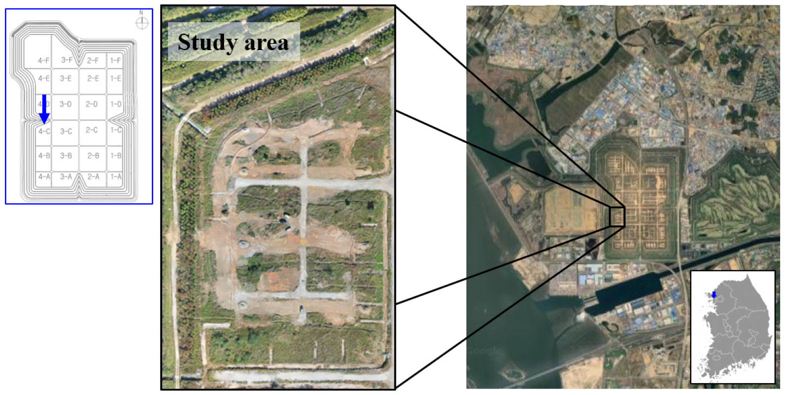
매립지에서 발생하는 환경오염을 효과적으로 관리하기 위해서는 신뢰도 높은 모니터링 기법의 적용이 필수적이며, 특히 3차원 공간 정보를 활용한 정밀 조사의 필요성이 높다. 본 …
- Effective management of environmental contamination at landfill sites requires the use of highly reliable monitoring techniques, and precise investigations that utilize three-dimensional (3D) spatial information are particularly important. In this study, a 3D inversion was performed using two-dimensional (2D) electrical resistivity survey data acquired from survey lines arranged in a grid pattern at the 2nd Sudokwon landfill site, and it’s the feasibility of this approach for landfill applications was examined. The survey was conducted through a combined inversion of data acquired with 5 m and 10 m electrode spacings to ensure shallow resolution and sufficient investigation depth. In addition, to analyze the effect of data density on the 3D inversion results, inversions were performed for two cases with survey line intervals of 25 m and 50 m, and the results were compared. The analysis revealed that 3D inversion using 2D survey data had a limitation: a grid-like pattern reflecting the survey line geometry appeared in the shallow subsurface, owing to its dependence on the input data. This methodological characteristic arises from the grid-shaped survey line configuration, and its effect tends to decrease with increasing depth. Nevertheless, the method effectively delineated the 3D spatial distribution of high-resistivity zones associated with the upper gravel cover layer and low-resistivity zones influenced by leachate, thereby confirming its potential as an economical and efficient 3D electrical resistivity investigation technique for landfill sites. Furthermore, narrower survey line spacing enhances spatial resolution, demonstrating that ensuring sufficient data density is critical for obtaining reliable 3D inversion results.
- COLLAPSE
매립지에서 발생하는 환경오염을 효과적으로 관리하기 위해서는 신뢰도 높은 모니터링 기법의 적용이 필수적이며, 특히 3차원 공간 정보를 활용한 정밀 조사의 필요성이 높다. 본 연구에서는 수도권 제2매립장을 대상으로, 격자 형태로 배치된 측선에서 획득한 2차원 전기비저항 탐사 자료를 이용하여 3차원 역산을 수행하고, 매립지에 대한 적용 가능성을 검토하였다. 탐사는 천부 해상도 확보를 위한 5 m 전극 간격 자료와 탐사 심도 확보를 위한 10 m 전극 간격 자료를 복합 역산하여 수행하였다. 또한, 자료 밀집도가 3차원 역산 결과에 미치는 영향을 분석하기 위해 측선 간격 25 m와 50 m의 두 경우에 대해 역산을 수행하고 결과를 비교하였다. 분석 결과, 2차원 탐사 자료를 이용한 3차원 역산은 입력 자료에 대한 의존성으로 인해 표층부에서 측선 형태의 격자 패턴이 나타나는 한계가 존재하였다. 이는 격자 형태의 측선 배치에 따른 방법론적 특성으로, 심도가 증가할수록 그 영향이 감소하는 경향을 보였다. 그러나 상부 자갈층에 의한 고비저항대와 침출수의 영향을 받은 저비저항대의 3차원 공간 분포를 효과적으로 파악할 수 있어, 경제적이고 효율적인 매립지 3차원 전기비저항 조사 기법으로서의 가능성을 확인하였다. 또한, 측선 간격이 좁을수록 공간 분해능이 향상되어, 신뢰도 높은 3차원 역산 결과를 얻기 위해서는 충분한 자료 밀집도의 확보가 중요함을 확인하였다.
-
A Feasibility Study on 3D Inversion of Grid-Based 2D Electrical Resistivity Data for Landfill Sites
-
Research Article
-
A Generalized Geometric Factor for 3D ERT Based on a Primary Electric-Field-Aligned Approach
3차원 전기비저항탐사에서 1차 전기장 정렬 기반 일반화된 기하학적 계수
-
Churl Hyun Jo
조철현
- Apparent resistivity is one of the most fundamental quantities used in the processing and interpretation of electrical resistivity tomography (ERT) data, and …
겉보기비저항은 전기비저항탐사 자료처리와 해석에서 다루는 가장 기본적인 물리량 중 하나이며, 그 값은 기하학적 계수에 의해 결정된다. 그런데 3차원 탐사에서 측선이 직선으로 유지되지 …
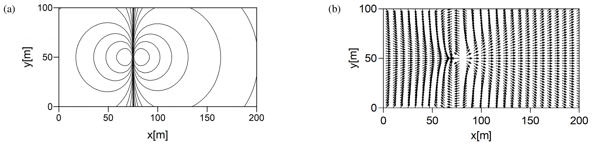
- Apparent resistivity is one of the most fundamental quantities used in the processing and interpretation of electrical resistivity tomography (ERT) data, and is determined by the geometric factor. However, when survey lines are not straight or when non-collinear electrode configurations are used in three-dimensional (3D) surveys, a generalized definition of the geometric factor is required. In this study, a generalized geometric factor is proposed using primary field-aligned virtual points, which are defined to align with the electric-field direction in a homogeneous half-space. These points are defined on a circle centered at the midpoint of a potential-electrode pair, allowing the geometric factor to be formulated consistently regardless of electrode orientation or survey-line geometry. Analytical verification shows that, except in limited regions near the current electrodes where electric-field curvature is large, the proposed method yields apparent resistivity values that are nearly identical to the true resistivity under homogeneous conditions. The proposed method provides a generalized basis for apparent resistivity calculations in 3D ERT with arbitrary electrode configurations.
- COLLAPSE
겉보기비저항은 전기비저항탐사 자료처리와 해석에서 다루는 가장 기본적인 물리량 중 하나이며, 그 값은 기하학적 계수에 의해 결정된다. 그런데 3차원 탐사에서 측선이 직선으로 유지되지 않거나 비공선형 전극배열이 사용되는 경우에는, 이에 적용 가능한 일반화된 기하학적 계수의 정의가 아직 정립되어 있지 않다. 본 연구에서는 이러한 문제를 해결하기 위해, 균질 반무한 매질에서 전기장 방향과 일치하도록 정의된 1차 전기장 정렬 가상점을 이용하여 일반화된 기하학적 계수를 제안한다. 이 가상점들은 전위전극쌍의 중앙을 중심으로 하는 원 위에 정의되며, 이를 통해 기하학적 계수를 전극배열의 방향이나 측선 형상과 무관하게 일관되게 정식화할 수 있다. 해석적 검증 결과, 제안한 방법은 전류전극 인근에서 전기장 곡률이 큰 제한된 영역을 제외하면, 균질 조건에서 진비저항과 거의 일치하는 겉보기비저항 값을 제공한다. 본 방법은 비직선 측선과 비공선형 배열을 포함하는 3차원 ERT에서 겉보기비저항 계산을 위한 일반화된 기반을 제공한다.
-
A Generalized Geometric Factor for 3D ERT Based on a Primary Electric-Field-Aligned Approach
-
Tutorial
-
A Tutorial on the Analytical Solution of Lamb’s Problem and Its Numerical Implementation
Lamb 문제 해석해와 수치 구현에 대한 해설
-
Sangin Cho, Sukjoon Pyun
조상인, 편석준
- Lamb’s problem is a core fundamental topic for understanding wave phenomena in seismology and geophysical exploration. This paper details the derivation of …
Lamb 문제는 지진학 및 물리탐사 분야에서 파동 현상을 이해하기 위한 핵심적인 기초 주제이다. 이 해설 논문은 2차원 반무한 매질 표면에 수직 점하중이 …
- Lamb’s problem is a core fundamental topic for understanding wave phenomena in seismology and geophysical exploration. This paper details the derivation of the analytical solution and its numerical implementation for a 2D semi-infinite medium subjected to a vertical point load on the surface. We derive the solution in the frequency-wavenumber domain using Helmholtz decomposition and Fourier transforms and present a step-by-step algorithm to reconstruct the time-space wavefield via the discrete Fast Fourier Transform (FFT). Comparing the implemented analytical wavefields with finite element method (FEM) modeling results confirmed that the travel times and waveforms of major seismic events match with high accuracy. This paper will serve as a useful guide for beginners to practically understand the basic concepts of elastic analytical solutions and their numerical implementation.
- COLLAPSE
Lamb 문제는 지진학 및 물리탐사 분야에서 파동 현상을 이해하기 위한 핵심적인 기초 주제이다. 이 해설 논문은 2차원 반무한 매질 표면에 수직 점하중이 작용하는 경우에 대한 해석해 유도와 수치적 구현 과정을 상세히 다룬다. 헬름홀츠 분해와 푸리에 변환을 이용해 주파수-파수 영역의 해를 유도하고, 이산 고속 푸리에 변환(FFT)을 통해 시간-공간 영역 파동장으로 복원하는 알고리즘을 단계별로 제시한다. 구현된 해석해 파동장을 유한요소법(FEM) 모델링 결과와 비교한 결과, 주요 파동의 도달 시간과 파형이 매우 정확히 일치함을 확인했다. 이 논문은 입문자들이 탄성파 해석해의 기본 개념과 수치적 구현 과정을 실무적으로 이해하는 데 유용한 지침이 될 것이다.
-
A Tutorial on the Analytical Solution of Lamb’s Problem and Its Numerical Implementation
-
Correction
-
Correction to Monitoring of Reinjected Leachate in a Landfill using Electrical Resistivity Survey
Correction to 전기비저항 탐사를 이용한 매립지의 재주입 침출수 모니터링
-
Chul Hee Lee, Su In Jeon, Young-Kyu Kim, Won-Ki Kim
이철희, 전수인, 김영규, 김원기
-
Correction to Monitoring of Reinjected Leachate in a Landfill using Electrical Resistivity Survey

Journal Informaiton
 Geophysics and Geophysical Exploration
Geophysics and Geophysical Exploration


한국지구물리물리탐사학회
대전 유성구 대학로 31, 한진오피스텔 1804호
Tel: 042-826-1804 / Fax: 042-826-1809 / E-mail: kseg@seg.or.kr Copyright© Korean Society of Earth and Exploration Geophysicists. Powered by APUB
Tel: 042-826-1804 / Fax: 042-826-1809 / E-mail: kseg@seg.or.kr Copyright© Korean Society of Earth and Exploration Geophysicists. Powered by APUB